| GEOIOO |
Name ________________________________________ |
| Earth, The Human Home | |
Test #l, Fall 2004 | Date ____________________ |
MULTIPLE CHOICE: Select the letter that best completes the statement, or answers the question.
Fill in that letter on the Scantron sheet (2 pts each).
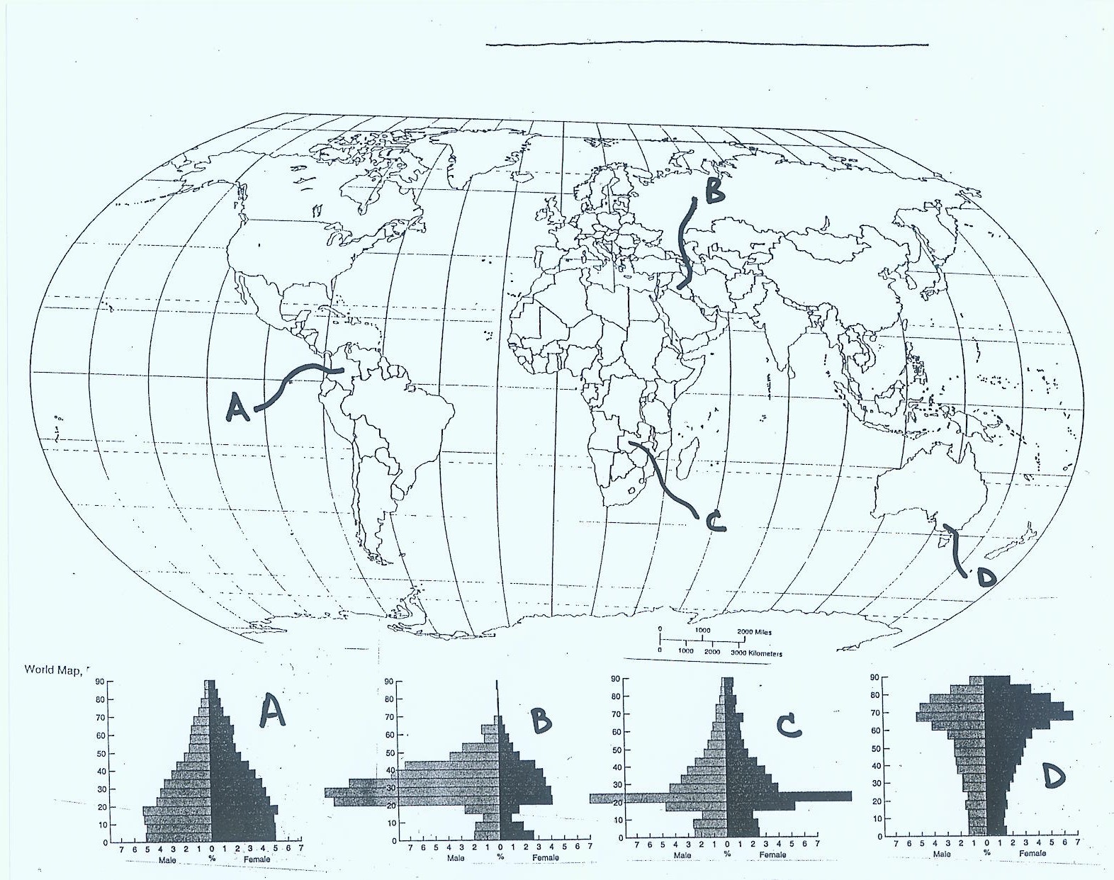
- Using the population pyramids on the last page of this exam, which pyramid best represents a
retirement community?
- There are approximately how many adults infected with HIV/AIDS in South Africa?
A. 0%-5%
B. 10% -15%
C. 25% - 35%
D. over 50%
- Of the following tools of the geographer, which is the most commonly used?
A. maps
B. the internet
C. drafting tools
D. surveying instruments
- Which of the following is NOT a way to show scale on a map?
A. representative fraction
B. graphic scale
C. ratio scale
D. magnetic direction scale
- The line on the globe at 23 1/2° south latitude is called the:
A. equator
B. Tropic of Capricorn
C. Tropic of Cancer
D. Tropic of Aquarius
- The census is taken in the United States to:
A. determine how many Mexican Americans have entered the United States
B. determine funding for anti-terrorism weapons
C. count how many illegal immigrants there are
D. determine the number of representatives each state has in the Congress
- Prior to 1940 most immigrants to the United States came from:
A. Europe
B. Asia
C. Latin America
D. Mexico
- The curve depicting human population dramatically increasing is:
A. 'P' shaped
B. "bow" shaped
C. 'J' shaped
D. 'S' shaped
- A form of ecological globalization is:
A. paving the nature preserve at CSUDH
B. creating the hole in the ozone layer
C. Paris fashions
D. the European Union
- Human geography:
A. deals with Earth's natural processes and their outcomes
B. does not deal with culture
C. is based on time space convergence
D. deals with the spatial organization of human activities and with people's relationship with
their environments
- Which of the following is a wrong designation for latitude or longitude:
A. 90° N
B. 113° S
C. 113° W
D. 170° E
- Currently we add approximately another one billion people to the world every ________ years.
- Using the map attached to the back of this test, which country is Iraq?
- Cornucopians believe ______________ will solve the pollution problem.
A. technology
B. strict pollution laws
C. a return to nature
D. fog brooms
- The theme for this course is:
A. globalization
B. mapping
C. states and capitals
D. physical geography
- The reason for the rapid increase in population is:
A. a dramatic rise in birth rate
B. large decrease in mortality rate
C. decrease in birth rate
D. aggressive government policies
- The term used to indicate the change in population due to immigration vs. emigration is called:
A. doubling time
B. natural increase
C. net migration
D. life expectancy
- Currently, the United States population is approximately:
A. 500,000,000
B. 294,000,000
C. 150,000,000
D. 983,000,000
- Knowledge skipping from one location to another location without people moving is called:
A. contagious diffusion
B. relocation diffusion
C. hierarchical diffusion
D. locational diffusion
- Using the supplied population pyramids (last page), which pyramid represents a college town?
- Which projection shows little distortion at the "mid-latitudes?"
A. conical
B. mercator (cylindrical)
C. planar (polar)
D. overhead
- At present the Earth's population is approximately:
A. 6,400,000
B. 4,500,000
C. 450,000,000
D. 6,400,000,000
- On the map attached to the back of this test, which city is Lusaka, Zambia?
- What percent of the world's population is in North America?
A. 73%
B. 12%
C. 8%
D. 5%
- Pre-adaptation means:
A. people are more likely to move to a place similar to the place they are leaving
B. you are born with knowledge about your culture
C. people re-evaluate their environment on an annual basis
D. Europeans are especially adapted to live in the desert southwest
- Today, the Prime Meridian runs through:
A. Paris France
B. London, England
C. Washington, D.C.
D. Greenwich, England
- Countries, which are economically and politically dominated by technologically advanced countries,
are said to be:
A. core regions
B. colonial countries
C. on the semi-periphery
D. on the periphery
- The spread of ideas through a region from contact, knower to knower, is:
A. contagious diffusion
B. hierarchical diffusion
C. wave diffusion
D. invention diffusion
- Thomas Malthus believed that:
A. population would increase faster than food production
B. people should use birth control
C. mad dogs and Englishmen go out in the noon day sun
D. that we were living at the top of the "S" shaped curve
- Which of the following is NOT one of the five fundamental themes of geography:
A. region
B. movement
C. diversity
D. location
TRUE - FALSE: Mark an A on the Scantron sheet if the statement
is true. Mark a B on the Scantron sheet if the answer is false
(2 pts each).
A = True
B = False
- A geographical imagination allows us to
understand changing patterns, processes, and relationships
among people, places and regions.
True
- Being on the edge of the Asian continent, Japan would be considered
"on the periphery."
False
- Access to education is considered a measure of standard of
living.
True
- One aspect of globalization is the incorporation of traditional
cultural systems.
False
- Lines of latitude are called meridians.
False
- Distance in miles is always the best way to explain how far
away something is.
False
- One aspect of globalization is the narrowing gap between rich
and poor.
False
- The Power of Place can be felt in a court house.
True
- Over population does not have a direct effect on our standard
of living.
False
- At the top of the 'S' shaped curve standard of living would be
diminished.
True
- Claudius Ptolemy is credited with assigning latitude and longitude
as a grid system for the Earth.
True
- Less educated women are likely to have more children.
True
- Globalization of economies has been led primarily by small productive
local corporations.
False
- Thomas Malthus was an economist.
True
- The baby boom population includes individual born after World War II
between 1946 and 1964.
True
- There are 60 seconds in one degree of latitude.
False
- Factors that contribute to migration are called push-pull factors.
True
- The title of a map should be directly related to the information
being displayed.
True
- Another term for birth rate is natality.
True
- The position of a desk in a manager's office says nothing about the
manager.
False